Skip Content
Find Your Senators
Alabama
Alaska
Arizona
Arkansas
California
Colorado
Connecticut
Delaware
Florida
Georgia
Hawaii
Idaho
Illinois
Indiana
Iowa
Kansas
Kentucky
Louisiana
Maine
Maryland
Massachusetts
Michigan
Minnesota
Mississippi
Missouri
Montana
Nebraska
Nevada
New Hampshire
New Jersey
New Mexico
New York
North Carolina
North Dakota
Ohio
Oklahoma
Oregon
Pennsylvania
Rhode Island
South Carolina
South Dakota
Tennessee
Texas
Utah
Vermont
Virginia
Washington
West Virginia
Wisconsin
Wyoming
MENU
SENATORS
Contact Your Senators
Leadership & Officers
Former Senators
Qualifications & Terms of Service
Facts & Milestones
States in the Senate
COMMITTEES
Membership & Assignments
Hearings & Meetings
History
LEGISLATION & RECORDS
Bills, Acts, & Laws
Nominations
Treaties
Votes
Floor Proceedings
Rules & Procedure
Landmark Legislation
Sessions of Congress
Senate Archives
Public Disclosure
ART & ARTIFACTS
Collection Search
Fine Art
Decorative Art
Historical Images
Historical Artifacts
Thematic Collections
Exhibitions & Publications
ABOUT THE SENATE
Officers & Staff
Vice President
President Pro Tempore
Secretary of the Senate
Sergeant at Arms
Party Secretaries
Chaplain
Committee & Office Staff
Pages
Powers & Procedures
Censure
Declarations of War
Expulsion
Filibuster & Cloture
Impeachment
Investigations
Nominations
Rules
Treaties
Voting
Origins & Foundations
The Senate & the Constitution
Electing & Appointing Senators
Committee System
Idea of the Senate
Parties & Leadership
Parties & Leadership
Historic Buildings & Spaces
The Capitol
Senate Chamber
Historic Rooms
Senate Office Buildings
Congressional Meeting Places
Past Senate Chambers
Traditions & Symbols
Oral History Project
Historical Highlights
1787-1800
1801-1850
1851-1877
1878-1920
1921-1940
1941-1963
1964-present
Senate Stories Blog
Research Tools
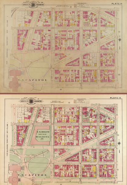
Baist Real Estate Atlas Maps, 1903 and 1909
Related Link:
Senate Stories | Square 686: A Capitol Hill Neighborhood Transformed
Maps from the
Baist's Real Estate Atlas
depict the transformation of Square 686 between 1903 (top) and 1909 (bottom), when the land was cleared to make way for the new Senate Office Building.
credit:
Library of Congress
Officers & Staff
Vice President
President Pro Tempore
Secretary of the Senate
Sergeant at Arms
Party Secretaries
Chaplain
Committee & Office Staff
Pages
Powers & Procedures
Censure
Declarations of War
Expulsion
Filibuster & Cloture
Impeachment
Investigations
Nominations
Rules
Treaties
Voting
Origins & Foundations
The Senate & the Constitution
Electing & Appointing Senators
Committee System
Idea of the Senate
Parties & Leadership
Historic Buildings & Spaces
The Capitol
Senate Chamber
Historic Rooms
Senate Office Buildings
Congressional Meeting Places
Past Senate Chambers
Traditions & Symbols
Oral History Project
Historical Highlights
1787-1800
1801-1850
1851-1877
1878-1920
1921-1940
1941-1963
1964-present
Senate Stories Blog
Research Tools